• 4 min de lectura
• 4 min de lectura
Capt. James Haley and Dana A. Goward
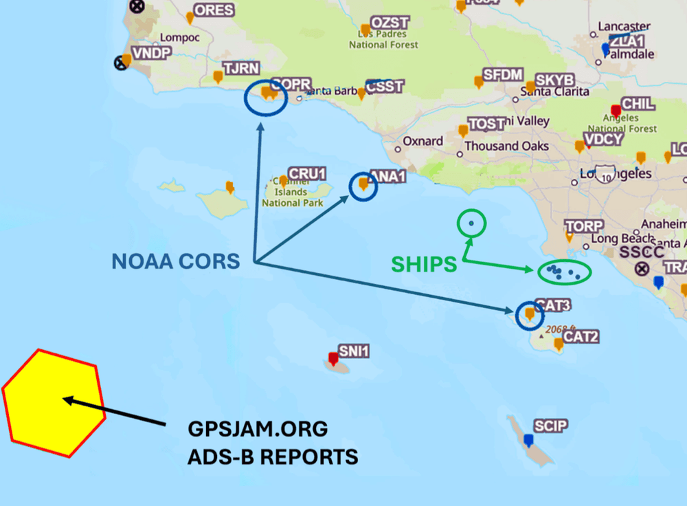
It was late at night on January 29, 2026. Seven ships approaching the Port of Long Beach from the west keyed their microphones on VHF Channel 14 to report GPS outages to the Los Angeles/Long Beach Vessel Traffic Service (VTS). Aircraft over the Channel Islands reported similar issues via ADS-B, while NOAA CORS sites recorded anomalies in L1 and L2 signal-to-noise ratios—all within the span of an hour.
While spoofing and jamming of global navigation satellite systems (GNSS) have become recurring problems in conflict zones, incidents like this demonstrate that no one is immune.
AIS reports from at least seven vessels showed position jumps consistent with GPS spoofing. At least one vessel's AIS transmission ceased altogether for nearly an hour, likely because of an invalid GPS/GNSS position solution. Available data indicates the event affected an area spanning more than 100 miles, including the critical Los Angeles/Long Beach Traffic Separation Scheme.
All of the documented GPS/GNSS anomalies occurred within a one-hour period, although the most dramatic position jumps reflected in AIS messages lasted only a few minutes. The brief duration of the event was likely the primary reason it had limited impact on positioning, navigation, and timing (PNT) and attracted little public attention.
The reported interference occurred between 11:00 p.m. and midnight local time under clear weather and good visibility, and all of the affected vessels ultimately entered port without incident. However, several ships were navigating in close proximity within the traffic separation scheme, where the loss of a reliable navigation solution could have degraded situational awareness and created dangerous distractions during a critical phase of their voyages.
Below is the AIS track of a large container ship showing position jumps that resulted in invalid and erratic course and speed-over-ground data.
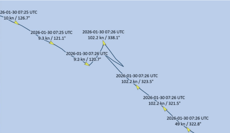 AIS track of a container ship showing abrupt GPS position jumps during the January 29, 2026, interference event. The vessel's reported speed briefly exceeded 100 knots and its course changed erratically before returning to its normal track, consistent with GPS spoofing or other GNSS disruption. Source: Capt. James Haley/Dana A. Goward
A tanker experienced similar position jumps.
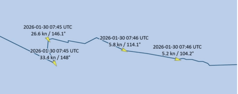 AIS track of a tanker showing anomalous GPS position jumps during the same January 29, 2026, event. The vessel's reported speed briefly increased to more than 30 knots before returning to normal, illustrating the effects of disrupted GNSS positioning. Source: Capt. James Haley/Dana A. Goward
On February 4, six days after the event, the minutes of the Los Angeles/Long Beach Harbor Safety Committee meeting recorded:
"GPS Outages: On the evening of January 29, VTS LA-LB received multiple reports of GPS outages from vessels in the LA-LB AOR. Sector personnel, with support from our port partners and the Coast Guard Navigation Center, were able to identify a GPS testing event as the likely cause."
While GPS testing is a routine occurrence, interference on the scale observed on January 29, 2026, is relatively rare.
The available data does not provide certainty, but the most likely source of the anomalies was a GPS test designated PMSRCA 26-02 (Point Mugu Sea Range California 26-02).
The U.S. Coast Guard Navigation Center publishes monthly GPS testing schedules for mariners. However, because GPS/GNSS anomalies are relatively uncommon in the Americas, many mariners may not have been aware of the planned testing. When GPS/GNSS signals become unreliable or unavailable, AIS can fail altogether or, even more concerning, continue transmitting and receiving false positions, courses, and speeds.
The takeaway for shipmasters, mates, and pilots is clear: crews should routinely practice and prepare to navigate in GPS/GNSS-denied environments.
As recent reports of space-based interference suggest, maritime navigation may be entering a new era of electronic warfare, raising the stakes for GPS/GNSS users around the world.
Captain James Haley is a senior consultant for UHU Technologies. He served for 32 years as a harbor pilot in Long Beach, CA.
Captain Dana A. Goward is President of the Resilient Navigation and Timing Foundation. He retired from the Senior Executive Service and served as the maritime navigation authority for the U.S.