• 4 min de lectura
• 4 min de lectura
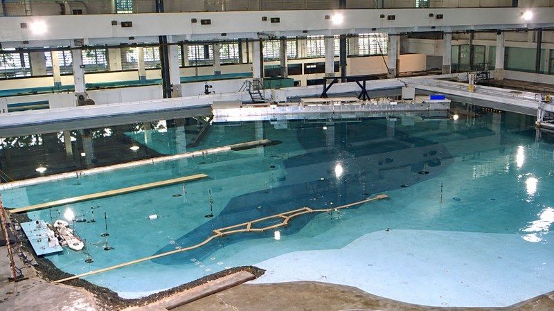
Can a river fit inside a laboratory? On a reduced scale, the answer is yes. This is how researchers from the National Institute for Waterway Research (INPH), linked to the National Department of Transport Infrastructure (Dnit), study water movement and the passage of convoys through sections with curves and strong currents.
With 3D printing, artificial intelligence, and simulations, the team seeks to identify navigation difficulties and evaluate solutions aimed at the safety and efficiency of waterways.
Currently, the INPH team is working on two models of sections that have curves and strong currents. One is in the evaluation and testing phase; the other is in the final stage of construction, before calibration. Both were designed to study conditions that can hinder the passage of convoys made up of barges and pushers.
Imagine a convoy of barges loaded with soybeans approaching a river bend. If a lateral current pushes the vessels, the maneuver can become more difficult. In the laboratory, researchers reproduce this situation to scale and observe how the convoy behaves under different conditions. The tests help identify passage difficulties and evaluate measures to make navigation safer.
Reproducing a river requires more than copying the shape of the bed and banks. For the tests to be useful, the water must also behave in the model in a similar way to that observed in nature.
For this, researchers use Froude's law of similarity, a principle that allows reproducing, to scale, hydraulic phenomena related to speed, flow, and the forces exerted by water.
After construction comes calibration, a stage in which measurements obtained in the laboratory are compared with data collected in the river to verify whether the model adequately represents real conditions.
With this correspondence established, the team can carry out tests and observe how currents influence the trajectory of vessels. The results help to recognize points that require greater attention during the passage and maneuvering of convoys.
The construction of a model begins with a topobathymetric survey, which records the characteristics of the terrain above and below the water. From this information, researchers create a "digital twin," a detailed virtual representation of the studied section.
This digital version is divided into parts, 3D printed, and assembled in the laboratory like a large puzzle. According to the Institute, digital manufacturing reduces construction time and increases the precision of the physical model, allowing for errors of less than one millimeter in construction.
The unit has been using digital manufacturing resources since 2022, including in projects for breakwaters and coastal protection structures. 3D printing expands this experience in waterway studies, by transforming data collected in the river into pieces that can be assembled and tested.
Before and during physical tests, numerical modeling programs allow evaluating different scenarios and hydrological conditions. The analyses consider historical series from the National Water and Basic Sanitation Agency (ANA). Computer-aided design programs, known as CAD, are also used in the creation of the digital twin.
In the laboratory, infrared tracking cameras monitor the water flow and the trajectory of convoys reproduced to scale. The records help specialists observe passage and maneuvering difficulties under different conditions.
The information collected in the river, in physical models, and in simulations is gathered in a maneuvering simulator. The tool allows evaluating, in real time and in a virtual environment, navigability conditions in different scenarios.
Each measurement, simulation, and test produces data that needs to be organized and analyzed. According to INPH, artificial intelligence resources, in the form of applied computational intelligence, assist in the analysis, validation, and cataloging of this information throughout the research.
The tools help compare results, but the interpretation of data and the evaluation of alternatives are up to the specialists. It is the combination of technology and technical knowledge that allows a better understanding of the difficulties encountered by vessels and the study of possible solutions.
By reproducing sections of rivers on the computer and in the laboratory, researchers can investigate how a current affects a maneuver and test different passage conditions. This knowledge provides technical support for decisions aimed at safer and more efficient navigation.